About GIS
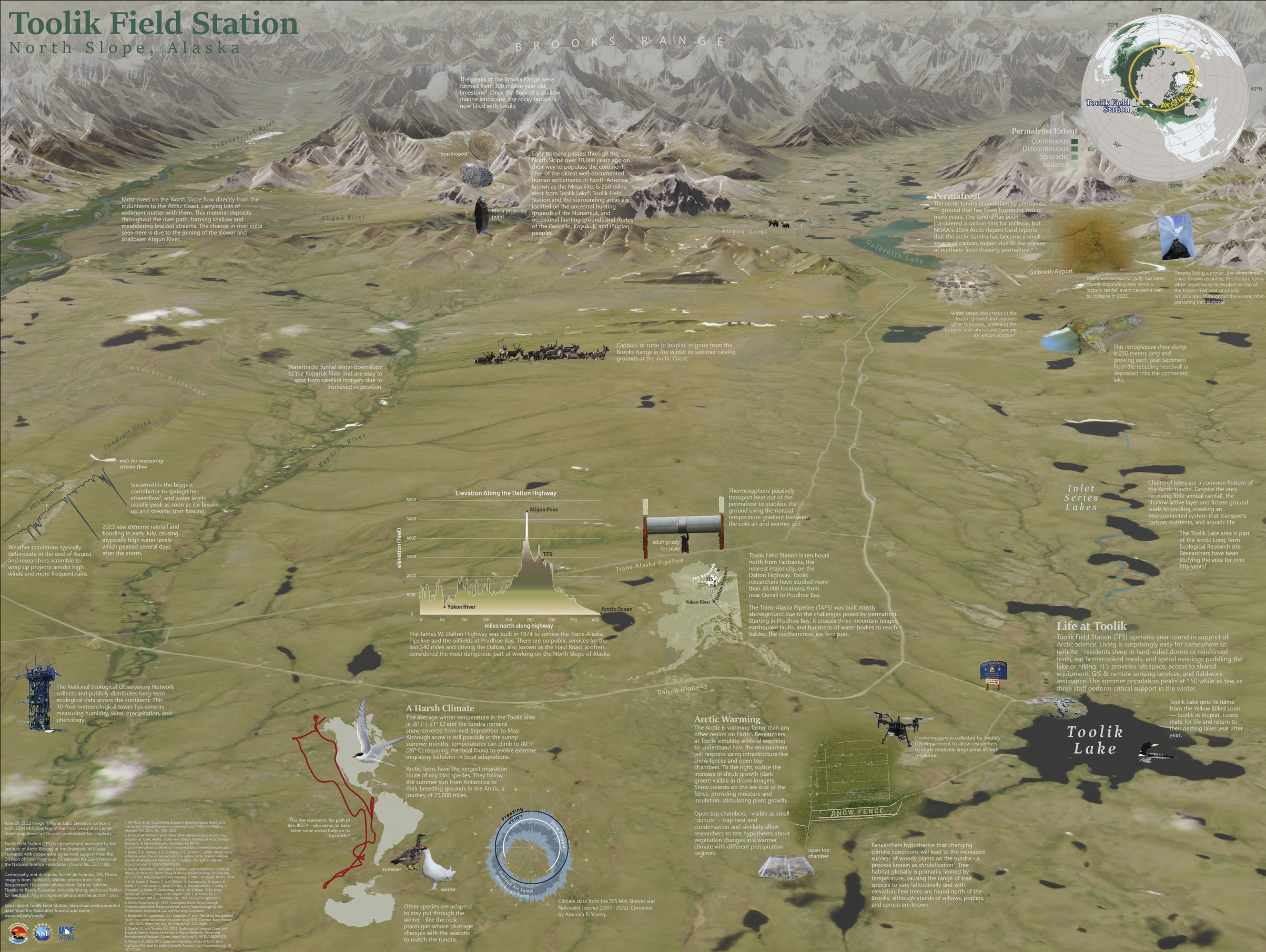
Toolik Field Station is located in the foothills of the Brooks Range on Alaska's North Slope and is administered by the Institute of Arctic Biology at the University of Alaska Fairbanks. Toolik Field Station was first established to support an aquatic program designed to obtain base-line data on the North Slope and inland coastal ponds in 1975. Research has expanded over the years to include terrestrial, atmospheric, vertebrate and other taxa, making Toolik home to a long running and diversified body of arctic ecology. The station currently supports a long-standing and rapidly expanding community of scientists and research projects representing individual and collaborative efforts from US and international institutions.
Growth of Toolik-based science, the number of researchers, and the facility from a tented camp to a research station prompted the establishment of the Toolik GIS (Geographical Information Systems) and Remote Sensing (RS) Program as part of the 5 year Cooperative Agreement between the National Science Foundation and the Institute of Arctic Biology, UAF in 2001 (NSF Award No. 9981914). The mission of this Program is to facilitate and enhance arctic research, and to increase research and management efficiency, effectiveness and capability. This is accomplished: 1) through Information Technology (IT) and GIS-RS support of administrative and management infrastructure and production of planning tools for land management and permitting, and 2) through direct consultation and GIS, RS, and GPS support services to scientists. ToolikGIS provides a rich spatial geodatabase, project-specific data development, spatial analyses, consultation and documentation. These services are available at the station during the summer field season and through the ToolikGIS office at UAF year round.
ToolikGIS is also committed to developing the database, hardware and personnel to anticipate future requirements and provide a legacy dataset to enhance the management and science conducted at Toolik Field Station and in the Arctic. Fulfilling the mission requires four basic types of activity: 1) maintenance, expansion and development of the Toolik GIS database, 2) timely response to short-term requests, 3) specialized project-specific data development and 4) active collaboration and publication of the results with research scientists. To date, the Toolik GIS and RS database includes several hundred spatial datasets comprised of vector data and attributes, and raster data from remotely sensed and derived sources. Staff are present on site throughout the summer field season and by request during the winter to provide on-site logistical, analytical and data development support in the office and in the field. Services are also available throughout the year to provide scientists, managers and administrators with the data, analyses and support necessary to maximize research and operations at Toolik.
ToolikGIS also plays an active role in the development and advancement of spatial data services at the regional and circumarctic scales. Involvement in the scoping and execution of arctic GIS efforts include participation in the North Slope Science Initiative (NSSI), the Study of Environmental Arctic Change (SEARCH), the NSF Arctic GIS Workshop, and other ongoing efforts.
The ultimate vision for the ToolikGIS program is to continue to provide a stable platform for enhancing and expanding scientific, managerial and administrative efforts at Toolik while acting as a key node in arctic spatial data services and distribution. In effect, ToolikGIS helps maximize the efficiency and effectiveness of efforts ranging from individual projects to multi-agency initiatives advancing our knowledge and management of arctic ecosystems.