

UAF provides the big picture in wildfire season
June 25, 2021
Rod Boyce
907-474-7185
The Geographic Information Network of Alaska, with support from the federal Joint Polar Satellite System program, uses data from two satellites orbiting 512 miles above Earth to provide fire managers with information vital to fighting wildfires in Alaska.
“From us you get frequent and fast image delivery, and those images show fire hot spots and fire extent,” GINA Director Jennifer Delamere said.
Data is downloaded and processed through software developed in nationwide collaborations and used across the country, rapidly producing images that show fire location, extent and intensity. It’s valuable information for wildfire managers — and the wider public.
GINA images help in fire detection and response. Wildfire managers, for example, detected two wildfires in mid-June by noticing their heat signature on the GINA images. An aircraft was sent to investigate each blaze. GINA imagery is also being used to assess the current Haystack fire extent, near a residential subdivision just north of Fairbanks off the Elliott Highway, and the Noatak River fire in Northwest Alaska.
In Alaska, the rapid production of images is made possible because Fairbanks lies under the orbits of the NOAA-20 and Suomi NPP satellites, launched in 2017 and 2011. These polar-orbiting satellites pass over Alaska as many as 18 times daily in the northern part of the state and up to eight times daily in Southeast Alaska.
“What makes UAF unique is that we have the antennas here in Interior Alaska to receive the data in near real time,” Delamere said. “A satellite flying over downlinks to us, we ingest the data into our computer systems and right away are making products. Within 15 to 35 minutes, products are going out to the user community.”
The two polar-orbiting satellites each carry an instrument called the Visible Infrared Imaging Radiometer Suite, or VIIRS, which provides information about wildfires and other aspects of the environment, according to the Joint Polar Satellite System, a program of NASA and the National Oceanic and Atmospheric Administration.
GINA, using data downlinked through UAF antennas on campus and at NOAA's site off the Steese Highway north of Fairbanks, produces a variety of high-resolution images to help wildfire managers.
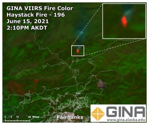
“If you want to know where the smoke is, the best image for that is what we call a true color image. That image replicates what your eyes see,” Delamere said. “If you want to know where fires are actively burning, you use our fire color image. If you want to estimate how hot a fire is, you would use our fire temperature image.”
GINA also examines the images to make sure that what shows up as a fire is actually a fire. That’s the job of Carl Dierking, GINA’s satellite liaison to agencies such as the Alaska Fire Service and National Weather Service.
“We're continually monitoring the data that we send out to make sure that it's the best quality,” Dierking said. “And if we see anything suspicious that might be noteworthy, we'll certainly inform our users about that. We’re probably more in tune to it if there's fires occurring.”
GINA provides information for the most publicly known wildfire mapping system, the Alaska Wildland Fire Information Map Series operated by the Alaska Fire Service and the Alaska Interagency Coordination Center.
"It helps to add a comprehensive picture of wildfires across the landscape," said Jennifer Jenkins, a geographic information system specialist for BLM Alaska Fire Service. "In Alaska, because we get multiple satellite passes a day, anyone using it can track the changes in wildfire and smoke."
GINA’s wildfire imagery will get even better next year with the scheduled launch of the Joint Polar Satellite System-2 satellite, which will also carry a VIIRS. Assuming the two current satellites remain healthy, Alaska’s wildfire watchers will benefit from having yet another set of eyes in the sky.
ADDITIONAL CONTACT: Jennifer Delamere, Geographic Information Network of Alaska, jsdelamere@alaska.edu , 907-474-7140