

Two-year project on coastal resilience wraps up in Goodnews Bay
October 20, 2017
Paula Dobbyn
907-274-9698

Goodnews Bay students have engaged in hands-on, professional science work to benefit their community and the state of Alaska during the past two summers.
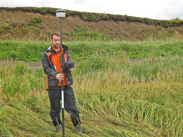
The students used ground-penetrating radar, Russian peat corers and GPS to help calculate the effects of climate change in their western Alaska village. They assisted researchers from the University of Alaska Fairbanks on a project to assess Goodnews Bay’s ability to adapt to flooding, erosion and other hazards associated with a warming planet.
“They were teaching the kids how to take measurements. We had cameras and they were learning how to shoot time-lapse video,” said Alice Julius, the village tribal environmental coordinator. “It’s good to show them the opportunities they have to be scientists in the future.”
The researchers were Chris Maio, a UAF professor of geoscience, and Ph.D. graduate
student Richard Buzard. Funded by Alaska Sea Grant to promote healthy coastal communities
and economies, their two-year project concluded in October 2017. The goal was to understand
the geology of the area and document sea-level fluctuations and beach erosion over
time to predict how Goodnews Bay would fare in the future and help residents prepare.
The researchers got approval from the local tribal council to work in the mostly Yup’ik Eskimo village, located between two rivers south of Bethel, a regional hub. Tribal administrator Peter Julius was instrumental in gaining the tribe’s permission for the research to go forward.
“Peter was of tremendous help with logistical support and introducing us to community elders,” Maio said.
Not much was known about Goodnews Bay geology or how its shoreline has shifted over the years. To fill knowledge gaps, Buzard researched aerial surveys done by the military in the 1950s and by NASA two decades later. He used the old surveys and modern geographic information system software, or GIS, to measure where the shoreline of Goodnews Bay was then and where it is today. Students from Rocky Mountain School, the village’s sole school, were involved in that process, along with community members.

“We put GIS units on their backs and had them walk the bluff edge, and we used that
elevation data to actually delineate the bluff and assess the topography,” Buzard
said.
The students also helped extract sediment cores from a salt marsh adjacent to the village to help figure out past drivers of coastal change, including sea-level fluctuations and storms. Maio sent the sediment core back to Fairbanks for analysis by undergraduates at the UAF Arctic Coastal Geoscience Lab. They were able to put together a chronology of past storm events using radiometric dating.
Jacquelyn Overbeck, who manages the state’s coastal hazards program, was impressed by the lengths to which Maio and Buzard went to involve young people in their work.
“That’s not always the case in scientific research,” Overbeck said.
Having students and residents trained in how to make shoreline profiles to measure
coastal erosion will help the community down the road, said Maio.
“They’ll be able to do it all on their own prior to and after major storm events,” he said.
This past summer, Maio and Buzard organized a community meeting to recap the project and provide the results. Between 40 and 50 people attended.
While munching on a pizza dinner flown in from Fairbanks, residents learned that Goodnews Bay is fairly resilient to the effects of climate change. Sea levels have been relatively stable during the past 1,500 years. That’s not to say some parts of the town aren’t vulnerable to erosion and flooding, including the low-lying airport and the shoreline in front of the village, which serves as a boat launch and safe harbor.
During a major storm in 2011, several outbuildings, a home and many smokehouses were destroyed. Elders also told the researchers that the entire village was relocated to higher ground in the 1920s due to flooding along the riverbanks.
Maio is seeking funding to do more coastal resilience research in western Alaska.
He and Buzard are currently working on another Alaska Sea Grant–funded project in 10 villages in the Bristol Bay region called Stakes for Stakeholders, with Overbeck as the principal
investigator. The team has trained residents to use time-lapse video and survey stakes to measure coastal, river and lake erosion. The data they collect will help communities
document and adapt to shoreline changes.
Learning from elders, inspiring students and spending time with community members are among the most satisfying aspects of the research in Goodnews Bay and other villages, Maio and Buzard said.
The work is not without challenges, though.
“Alice attempted to teach us how to clean salmon with an ulu. But, seeing how we massacred the fillets, she decided we better just stick to cleaning up the carcasses,” said Maio.
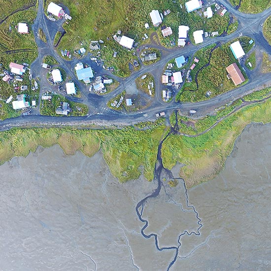
VIDEO: See Goodnews Bay from the air in drone footage shot by Richard Buzard, summer 2017