

Tsunami awareness a priority decades after last major Alaska event
March 26, 2021
Rod Boyce
907-347-9105
The Alaska Earthquake Center has created tsunami awareness brochures for the cities of Valdez and Unalaska, and it hopes to expand the effort to cover all of Alaska’s coastal communities.
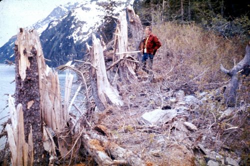
The center has long sought to raise awareness about tsunami risks. Fifty-seven years ago this Saturday, March 27, earthquake-triggered tsunamis devastated towns along Alaska’s southern coast and killed 124 people, some even in Oregon and California.
The brochures, intended to save lives in such a scenario, are designed to fit in a pocket or purse. They contain information for coastal residents and visitors in easy-to-understand language.
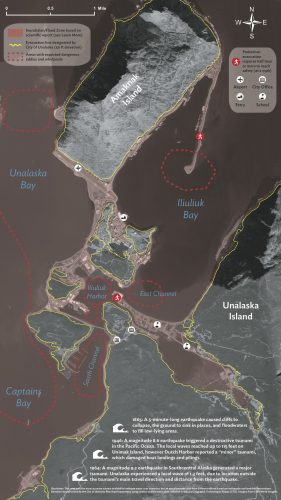
Each brochure also contains a detailed color map showing the inundation zone and safe places near the cities.
“I hope every household will get one,” said Elena Suleimani, tsunami modeler with the Alaska Earthquake Center, part of the University of Alaska Fairbanks Geophysical Institute. “Then the people will start asking questions about how to evacuate, where, how to get the warning message, etc. The goal is to generate questions and concerns that local authorities will have to address.”
Suleimani is co-author of the Valdez and Unalaska inundation mapping reports and assisted with the brochures’ text and maps. She said the two communities were chosen because of their high tsunami hazard and because they represent different regions of Alaska.
On March 27, 1964, a magnitude 9.2 earthquake in Prince William Sound unleashed several tsunamis. They wiped out the village of Chenega and damaged Whittier, Seward, Kodiak and Valdez. Recalling that disaster, Alaska Gov. Mike Dunleavy proclaimed this week to be the annual Tsunami Preparedness Week.
Each brochure produced by the earthquake center includes a map showing the evacuation zone as determined by city officials. They show locations of shelters and other safe areas and include information on how long it would take a person to reach safety. They also point out locations of possible dangerous eddies and whirlpools.
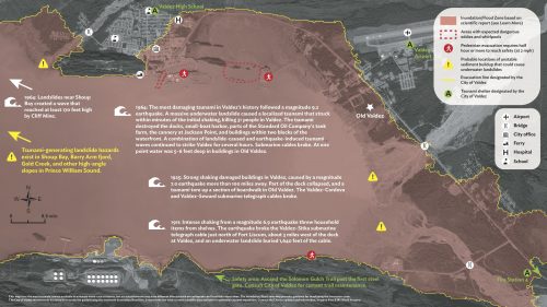
The Valdez map includes an extra warning about the risk of landslide-generated tsunamis occurring along Shoup Bay, Barry Arm fjord, Gold Creek and other high-angle slopes in Prince William Sound.
Valdez has 5,200 brochures; Unalaska has 1,500.
“The brochure is a key component of education in the city,” said Aaron Baczuk, Valdez’s emergency manager. “Much of its content is a direct manifestation of years of dedicated effort within the scientific community in Alaska.”
The city intends to blanket the area with the brochures, sending them to every post office box and putting them at key locations such as City Hall, the harbor, the visitor center and at least 20 businesses.
Unalaska officials will spread the brochures around their city as well, said Bill Simms, deputy chief of police at the Unalaska Department of Public Safety.
Other Alaska communities have asked for such brochures.
“We’re looking for a way to make this possible for all coastal communities in Alaska,” said Michael West, director of the Alaska Earthquake Center.
“We had damaging tsunamis in 1938, 1946, 1964, 1965 and then nothing,” he said. “We have grown complacent, and I don't mean that in a critical sense, but most people living in coastal Alaska today have not actually experienced a tsunami.”
The new brochures, and any that will follow for other communities, build on the interactive tsunami inundation map that the Alaska Earthquake Center launched in 2019. The map can be found online at https://earthquake.alaska.edu/sites/all/tsuMap/html/tsunami.html.
Download the Valdez brochure here.
Download the Unalaska brochure here.
ADDITIONAL CONTACT: Lea Gardine, Alaska Earthquake Center seismologist and cartographer, lagardine@alaska.edu or 907-474-7664
NOTE TO EDITORS: A longer story about the brochures is available on the Geophysical Institute website at www.gi.alaska.edu.