

Satellites fill void for wildfire managers amid COVID-19 restrictions
June 3, 2020
Tom Moran
907-474-5581
Fortunately for the Alaska's state and federal fire services, COVID-19 doesn’t affect satellites.
While restrictions related to the virus have made it more difficult for fire managers to rely on traditional ground observations to keep track of conditions in the field, their satellite sensing capabilities are intact. And they’re getting a boost from University of Alaska Fairbanks-based researchers and the National Science Foundation.
Scientists with the Alaska NSF Established Program to Stimulate Competitive Research (EPSCoR) are helping the fire services by contributing their own expertise to this increasingly important aspect of fire readiness and response.
“Many of the things that people were comfortable doing in the past have been severely restricted this year,” said Robert Ziel, a fire analyst for the Alaska Fire Science Consortium and also an EPSCoR researcher. “The ability to assess snow cover, the ability to assess green-up, the ability to display these kinds of things and highlight them for decision-makers, is taking on a greater level of importance because they're not able to to go out and see it for themselves.”
In mid-April, EPSCoR scientists raised a simple question to Ziel and other fire agency representatives: What can we do to help? The brainstorming session that followed generated potential projects, most of which involved tailoring or building remote sensing products for the fire services. They mostly fell onto the shoulders of UAF postdoctoral researcher Chris Waigl.
“The end of these conversations that I ran with, was that there were three products that would be really useful to the fire service if they had them available in a usable form,” Waigl said.
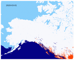
Waigl’s first project was to provide maps of Alaska’s diminishing snow cover by processing data from the U.S. National Ice Center and uploading it onto agency fire maps. The project provides fire managers with information about fire risk, but also helps them determine which remote weather stations are snow-free and can resume automatic functioning. Waigl has been updating the maps on a daily basis and has established an almost fully automated process to continue providing them.
Waigl will follow that up with the second task, providing statewide maps of the “Smokey Bear” fire danger ratings — low, medium, high, very high and extreme. Maps of these ratings are produced by a group in Utah, and are not currently compatible with Alaska Fire Service maps.
“They had to juggle two different websites to visually compare,” Waigl said. “But this data is also produced in a form that I can transform into something they can use, and that’s what I’m doing next.”
Waigl’s third project is the most ambitious, but it’s also one for which she is well-prepared. As a graduate student at UAF, she led a team that designed a process called VIFDAHL (VIIRS I-band Fire Detection Algorithm for High Latitudes), which tailors existing satellite fire-detection techniques for Alaska's specific conditions. That enables it to detect fires, especially low-intensity blazes, with more accuracy than the available products.
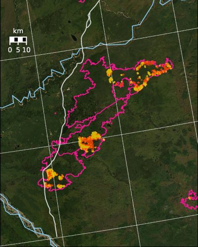
Last summer, Waigl was hired by EPSCoR to use VIFDAHL to generate better maps of the Shovel Creek Fire near Fairbanks, in direct response to requests at a community meeting about the fire. She created twice-daily maps of Shovel Creek and other significant fires, which indicate not just flaming fronts but also lower-intensity burns located away from the main fire centers. The project served as a valuable proof-of-concept on VIFDAHL, as well as a lesson in data processing and formatting.
“It demonstrated to the fire service that this was something they wanted, and what it also helped us do last year was to figure out what a suitable way is to produce this data so that the fire service can use it,” Waigl said.
Now Waigl is embarking on a project to apply these techniques on a larger scale. Waigl will use VIFDAHL to analyze both major fires around the state and nascent fires in high-risk areas, and to provide the data each day to the fire service to update its main incident map. In addition to timely fire data, Waigl also noted the VIFDAHL maps can be used for future research into fire ignition.
Ziel said Waigl’s efforts will help firefighters by providing them with up-to-date, easily accessible information. That data can be used to make informed decisions on when and where to allocate resources, both in general and for specific fire events.
“They have aircraft that need to be prioritized on a given day, they have crews that need to be dispatched to priority fires,” he said. “And so having that fire danger information in the context of those values allows us to more quickly identify which fires are most important.”