

Recharging the overwintered Alaska battery
April 20, 2015
Ned Rozell
907-474-7468
4/20/2015
It has been a long winter. Like many Alaskans, I have a love/hate relationship with this oversized peninsula, especially as the months of dark and cold pile up like woodstove ash. When the sun returns, I feel a need to recharge my affection.
One way to do this is to visit new parts of this immense, varied place. For more than 20 years, my job as a science writer with UAF's Geophysical Institute has often been my vehicle to the difficult and awesome: Lituya Bay with glaciologists, Attu with biologists, St. Lawrence Island with a climatologist, Katmai caldera with a volcanologist, the top of Denali with Japanese climbers, an abandoned radar station (with a polar bear inside) in a place called Lonely.
My dream is to open the Alaska Atlas and Gazetteer and have a memory on each page. I am getting there.
Last week, I joined five friends on a cross-country ski trip across the Seward Peninsula, the nose of Alaska that points towards Russia. The team — including a biologist, two hydrologists and geologist — skied from Shishmaref to Nome. The wind erased the trail behind us.
Ed, John, Robin, Bob and Brian were not on the trip to make measurements or otherwise perform science. They wanted to see, smell and slide across new country, about 200 miles that included two hot springs with tubs, Serpentine and Pilgrim.
I was attracted by the hot springs, the crossing of the continental divide at one of its lowest points, and place names like Brakes Bottom, Coffee Dome and Marys Igloo. I had mental images of what the trip would be like. The trail brushed them away and redrew them.
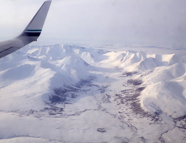
Unlike this one, my next few columns will be based on science topics unearthed during the eight-day journey across the former Bering Land Bridge, now a jagged landmass wearing an apron of flaky sea ice. First, though, a few observations from the sublime window-seat view from Fairbanks to Anchorage to Kotzebue to Nome to Shishmaref.
After climbing through the white chill of Interior Alaska, the hills south of the Alaska Range were spruce green at the end of what those in Anchorage will remember as the Year Without a Winter. The only hint of the season down there was the whitish ice covering lakes.
While taking off in a 737 for Kotzebue from Ted Stevens International, I saw a golden plover standing calmly in the grass between giant whining airships. The lovely bird with a white mane that resembles a fur ruff was an early arrival from Hawaii or other parts south. Maybe it was, like us, on its way to the tundra near Shishmaref.
The Anchorage-centric brown-winter view vanished as the jet climbed over the western curve of the Alaska Range. There, a tumble of mountains spilled from the shoulder of Denali to the blue/white volcanoes of the Aleutian Range. There, I felt it: the assurance that, above all that quiet drama and with the sun climbing to its seasonal throne, you are where you belong.
The plane reached cruising altitude over one of the few roads it would cross in 500 miles, the old mining trail from Poorman to Ruby. The Yukon, sinuous and stenciled in blue, gurgled clear under ice that won't move until May.
Next appeared a white splotch on the landscape, the Nogahabara Dunes. Six miles in diameter, the dunes are a sandy pimple on Alaska, far enough from everything that they remain a happy mystery not dented with bootprints.
From there, we passed over a line on the National Geographic map that would become significant the following days: "Limit of Wooded Country." Below the raw, windswept surface was carved in sastrugi drifts. Life there is different from the gentle boreal forest of Fairbanks.
After a landing to pick up passengers at Kotzebue, we arced southwest to Nome, passing over Devil Mountain Lakes, two roundish water bodies created when magma explosively met permafrost near the height of the last ice age. The largest mars on Earth looked as peaceful as the surface of the moon.
I landed in Nome feeling lightened by the silent, unpeopled beauty of my adopted state. An orange moon crawled through the spiderweb of utility wires on 1st Avenue as the sun set at 10 p.m. Inside a rented house, we sorted gear for the next day's flight to Shishmaref and the start of a journey that would boost my Alaska battery back to 100 percent.
Since the late 1970s, the University of Alaska Fairbanks' Geophysical Institute has provided this column free in cooperation with the UAF research community. Ned Rozell is a science writer for the Geophysical Institute.