

New online science gateway to offer insight into changing Arctic conditions
October 22, 2019
Jeff Richardson
907-474-6284
A new online scientific resource will document changing permafrost conditions at the sub-meter scale throughout the Arctic, providing researchers, educators and the public with new opportunities for exploration and discovery.
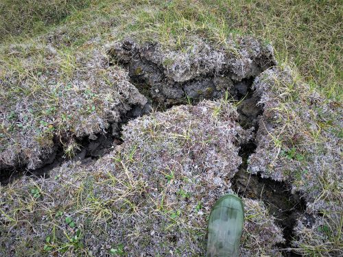
The Permafrost Discovery Gateway, funded by a $3 million National Science Foundation grant from the Navigating the New Arctic initiative, will use satellite images and high-performance computing to document and display a variety of changes in the Arctic. Phenomena such as coastal erosion, landslides and thawing ice-rich permafrost will be combined with air temperature and precipitation maps. Together, the resource will help users form a detailed picture of Arctic change with a focus on thawing permafrost, providing information that can ultimately help inform policies and management in the Arctic.
Researchers from the University of Alaska Fairbanks, Ohio State University, the University of Illinois, the University of Connecticut, and the Arctic Data Center at the National Center for Ecological Analysis and Synthesis will lead the development of this online resource. They’ll work with the Alfred Wegener Institute, NASA, the Center for Climate and Health at Alaska Pacific University, and the Polar Geospatial Center at the University of Minnesota.
UAF researcher Anna Liljedahl, the project leader, said the platform will be a user-friendly tool to explore a region that is being rapidly altered by climate change. The four-year effort, which will begin on Nov. 1, will be designed for use by both scientists and the public.

The online resource will include tools for visualization, analysis and processing of big imagery. Those features will allow users to document, explore and understand changes that have occurred in the Arctic, both large and small.
“The Permafrost Discovery Gateway will be a place for people to play with big datasets so that diverse peoples can create knowledge that is useful for them,” said Liljedahl, who works at UAF’s Water and Environmental Research Center.
Researchers from around the world have been collecting data about the Arctic for decades, including some of the information that will be used in the project. The Permafrost Discovery Gateway aims to make this information more accessible to everyone, since it is otherwise scattered across various locations or is too large to explore without technical expertise or access to supercomputers.
Liljedahl said an early version of the Permafrost Discovery Gateway will be available within a year. The research team will add features, refine the design and populate the online resource as the project continues, while gathering user feedback to guide its evolution.
“I think it’s unlike anything out there,” Liljedahl said. “Our combination of resources within the gateway can finally help people keep up with the rapidly changing Arctic landscape as it is transforming and at a scale that is relevant to people.”
The project webpage is available at https://permafrost.arcticdata.io/.
ADDITIONAL CONTACT: Anna Liljedahl, akliljedahl@alaska.edu