

NASA lidar on Elvey Building provides cloud data
August 3, 2017
Sue Mitchell
907-474-5823

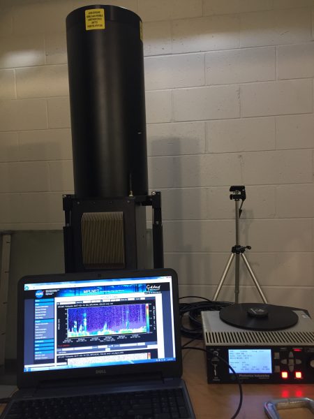
A rapidly blinking green light beam has been flickering skyward through a foot-square quartz window in the north corner of the roof of the Geophysical Institute's building since October 2016. It's on all the time, quietly collecting data. The device is giving scientists around the world useful, detailed information about the height, structure and content of clouds and aerosol layers over Fairbanks.
"Would you or I be able to go outside and see what precise height the clouds are? Well, now we have a tool that can do that," said Javier Fochesatto, associate professor of atmospheric sciences at the University of Alaska Fairbanks.
The pulsing green light on the Elvey Building comes from a lidar, which stands for "light detection and ranging." This particular device is a micropulse lidar, an eye-safe system capable of determining the geometric and optical properties of atmospheric particles and clouds. It fires an extremely short pulse of laser light at a specific wavelength — 532 nanometers — and measures the time from pulse transmission to reception of the return signal.
The device is part of NASA's global Micro-Pulse Lidar Network. The MPLNET at the Geophysical Institute sustains collaborations with U.S. universities, the Naval Research Laboratory and the National Research Council of Italy.
Knowing the exact elevation of droplets of water or ice that make up clouds can tell you a lot about the cloud's composition and the dynamic processes which aid in formation of those clouds, Fochesatto said.
"The littlest amounts of liquid super-cooled water at polar temperatures can become a source of nucleation (tiny particles that serve as ice nuclei)," he said. "Then it will easily develop an ice cloud that has the potential for causing dangerous icing on aircraft wings."
Studying clouds is an important part of atmospheric research, Fochesatto said.
"Clouds are one of the very important components of the cycle of water," he said. "Clouds are like funnels channeling water through the atmosphere, connecting ecosystems across the planet. As well, they are of strategic interest since they can transport biological material across long distances."
Fochesatto and his graduate students will be able to use the data from the lidar for research in a wide variety of studies, such as atmospheric boundary layer research related to smoke and particulate matter important to air quality studies and climate modeling. The MPLNET data are collected continuously, day and night, over long time periods from sites around the world. All the data collected by all the sites is continuously available at mplnet.gsfc.nasa.gov/data.
Clouds have an enormous influence on the Earth’s climate and weather, according to NASA publications. In order for scientists to create increasingly realistic computer simulations of Earth’s current and future climate, they’ll have to include more accurate representations of the behavior of clouds, and the MPLNET system is one of only a few ground-based sources of those data representing polar and sub-Arctic latitudes. Key focus areas for MPLNET research include U.S. and international aerosol and cloud research, climate change and air quality studies, support for NASA satellite and sub-orbital missions, and aerosol modeling and forecasting.
UAF has a three-year agreement with NASA to operate and maintain the lidar, but Fochesatto hopes that agreement can be renewed as more researchers are gradually drawn to the dataset. MPLNET is composed of NASA sites and others run by, or with help from, partners from around the world.
Fochesatto’s research focuses on micrometeorology and atmospheric boundary layer research, and this includes tropospheric aerosols and clouds. Additional instruments are installed on the Elvey Building roof to collect cloud, aerosol and atmospheric thermodynamic data. For example, a polarimetric lidar operates in the near-infrared region combined with surface radiation sensors. Additional instrumentation is under development, to be funded by NSF, that will combine polarimetric and Raman spectroscopy to provide data about cloud composition in terms of ice and supercooled water, as well as optical properties of cloud layers through scattering processes in the atmosphere, when the lidar light beam interacts with tiny particles or with ice.
ADDITIONAL CONTACT: Javier Fochesatto, gjfochesatto@alaska.edu
ON THE WEB: MPLNET, https://mplnet.gsfc.nasa.gov/; free Fairbanks MPLNET data, https://mplnet.gsfc.nasa.gov/data?s=Fairbanks&v=V3
Story by LJ Evans