

Glaciers no obstacle for Copper River and Northwestern Railway
January 18, 2012
ASF#2097
Jan. 11, 2012
By Ned Rozell
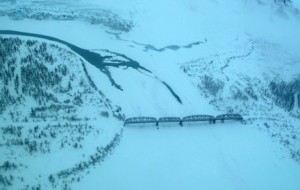
Home of the trans-Alaska pipeline, Alaska has been the setting for a few
epic engineering battles rendered against nature. The Million Dollar Bridge,
spanning the lower Copper River, is a reminder of another improbable Alaska
construction project.
Completed in 1910, the Million Dollar Bridge was the crux of the Copper
River and Northwestern Railway, built to carry copper ore 196 miles from
Kennicott to Cordova. Along that route were some of the greatest obstacles
Alaska offers: steep canyons, rivers, hurricane-force winds, mosquitoes,
and dozens of glaciers.
A fortune in high-grade copper locked deep in the Wrangell Mountains
inspired Outside investors, including the Guggenheim family and J.P. Morgan,
to risk building a railway from an ice-free port on Alaska's southcentral
coast to the rich copper deposits at Kennicott. In 1906, planners
recommended four possible routes to the copper - including two from Valdez
to the Copper River via 2,000-foot passes - but railroad builders chose a
route from Cordova that would follow the Copper River north to Chitina, then
continue 60 miles to Kennicott.
Glaciers stuck out their tongues in defiance along the entire route, but the
pull of financial gain and human ingenuity overcame them. In one case,
workers laid tracks across the debris-covered ice of Allen Glacier for
five-and-one-half miles, according to my two sources for this column, The
Copper Spike by Lone Janson and Iron Rails to Alaskan Copper by Alfred
Quinn.
Two of the largest obstacles on the route were Miles and Childs glaciers,
both of which calve icebergs into the Copper River from opposite banks.
Erastus Hawkins, the engineer in charge of the railroad project, and Michael
Heney, the construction contractor, preferred to run the railroad alongside
the Copper River, but the Miles and Childs glaciers sprawl over both
shorelines at a pinch-point about 15 miles from the river¹s mouth. Not
listening to other engineers who thought the problem was insurmountable,
Hawkins designed a 1,550-foot steel bridge to span the Copper River at a
river bend between the two glaciers.
Geologists had found that the glaciers had fused during the past several
centuries, and the leader of a U.S. Army expedition up the Copper River in
1885 reported that the nose of Miles Glacier was then about 120 yards from
the site of the bridge. By 1908, both glaciers had receded to provide a gap
of about three miles.
Starting in April 1909, workers scrambled to complete the Million Dollar
Bridge, spurred on by a U.S. law that gave railroad developers four years to
complete a designated route. After four years, the government would tax them
$100 per operating mile per year. Contactors finished the bridge by
midsummer of 1910.
Soon after construction of the Million Dollar Bridge, which cost $1.4
million to build, the glaciers continued to threaten the railroad.
In August 1910, two glaciologists from the National Geographic Society
studied the sudden advances of both Miles and Childs glaciers. A northern
lobe of Childs Glacier began creeping toward the bridge in June, and by
August it was moving eight feet per day. On August 17, the 200-foot face of
the glacier was 1,624 feet away from the bridge.
Ralph Tarr, one of the glaciologists, speculated on what would happen if the
glacier continued to advance in 1911.
"It is absolutely certain that no corps of engineers could save the bridge
and railway if the glacier should advance that far," he wrote.
Childs Glacier did not engulf the bridge, but the glacier crept to within
1,475 feet in June 1911. Childs and Miles glaciers have since retreated,
sparing the Million Dollar Bridge, which served the railway from 1910 until
1938, when low copper prices forced the shutdown of the Copper River and
Northwestern Railway. The bridge survived nature's whims until March 23,
1964, when the Good Friday Earthquake knocked the northernmost span from its
concrete piling, a flaw that state workers repaired in 2005.
This column is provided as a public service by the Geophysical Institute,
University of Alaska Fairbanks, in cooperation with the UAF research
community. Ned Rozell is a science writer at the institute. This column
first appeared in 2002.