

SNAP offers interactive climate change maps
SNAP offers interactive climate change maps
Submitted by Nancy Tarnai
Phone: 907-474-5042
11/06/08
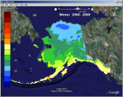
The public can now access the statewide climate scenario maps used by the governor’s Climate Change Sub-Cabinet in its statewide planning efforts.
The maps use the free global mapping program Google Earth to display data from the Scenarios Network for Alaska Planning. SNAP is the policy and research component of the University of Alaska Geography Program, which is part of the UAF School of Natural Resources and Agricultural Sciences. Recently, the program and SNAP collaborated with Google and the National Geographic Society to bring climate models and related information to K-12 educators in Nome, Kotzebue and Barrow. The geography program serves as the National Geographic Society’s K-12 and outreach office for the state of Alaska.
Available maps and data include projections of average summer and winter temperatures by decade, as well as month-by-month projections for every year from 1980 to 2100. Maps are available for three different greenhouse gas emission scenarios: low, midrange and high. All maps are at 2-kilometer resolution, which allows users to pinpoint regions and communities. Google Earth features allow users to select scenarios, zoom in and out, pan across the landscape and animate selected time series.
The maps are based on models used by the Intergovernmental Panel on Climate Change. SNAP collaborator and UAF researcher John Walsh and colleagues determined which five IPCC models performed best in Alaska and linked those model outputs to climatology that takes into account local topographic features and weather station data.
About SNAP
SNAP is a collaborative network that includes the University of Alaska, state, federal,
and local agencies, nongovernmental organizations and businesses. Its mission is to
provide objective data and relevant scenarios of future conditions in Alaska for people
who make policy, management and economic decisions. Alaska is undergoing rapid changes
in climate, human population and demands on natural resources. Future planning that
accounts for these changes can reduce costs and liabilities.
CONTACT: SNAP program coordinator Nancy Fresco, 907-474-2405 or via e-mail at ffnlf@uaf.edu. SNRAS public information officer Nancy Tarnai, 907-474-5042 or via e-mail at fnnjt@uaf.edu.
ON THE WEB: www.snap.uaf.edu
Google Earth can be downloaded from www.googleearth.com.
NT/11-6-08/062-09